Areas west of Kamloops are at a higher risk of flooding this spring, with alpine snowpacks well above normal for this time of year in those places.
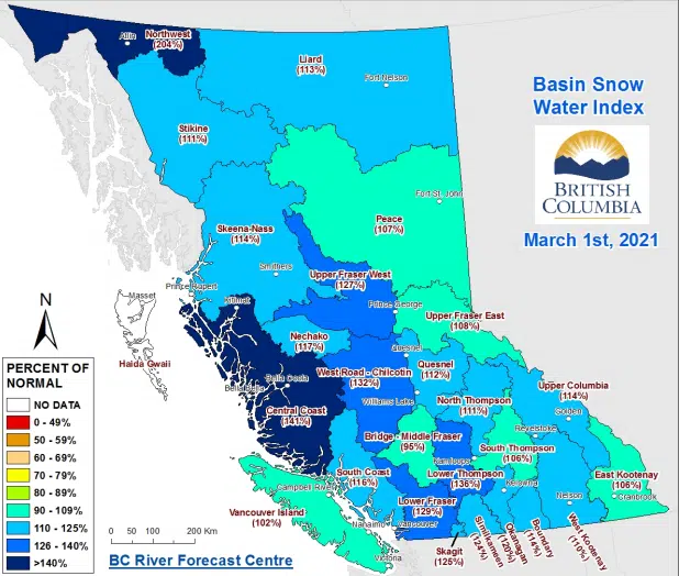
In its update snowpack bulletin released today, with data up to March 1, the BC River Forecast Centre says the Lower Thompson snow basin has an average snowpack of 36 per cent above normal. That snow basin includes everything that feeds into the Thompson River between Kamloops Lake and Cache Creek.
Cache Creek, in particular, has experienced flooding during the spring snow melt in four of the past six years.
Hydrologists tell NL News regularly that any snowpack value 20 per cent above normal or higher represents a potential risk of flooding.
The Nicola snow basin is also high at this point, at 19 per cent above normal.
In other areas close to Kamloops, the alpine snowpacks are much closer to normal. The North Thompson basin is 11 per cent above normal, while the South Thompson basin is six per cent above.
“Due to cooler temperatures during spring months, La Niña conditions often result in continued snow accumulation and delayed snow melt,” the snowpack bulletin says. It adds that alpine areas in the southern Interior typically see snowpacks rise by 10-17 per cent between March 1 and May 1.
Province-wide, the average snowpack value in B.C. on March 1 was 14 per cent above normal. That’s up modestly from 11 per cent above normal on Feb. 1 and eight per cent above normal on Jan. 1.


