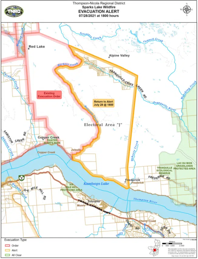
The Thompson-Nicola Regional District has lifted an evacuation order for 110 properties near the Sparks Lake wildfire.
Those properties northwest of Kamloops, on Dale Road, Frederick Road, Harbridge Drive, Meadow Road and Tranquille-Criss Creek Road were evacuated on July 13 because of the blaze. But as of Wednesday night the order has now been downgraded to an alert.
There remains almost 190 properties within the TNRD on evacuation order from the Sparks Lake fire, with hundreds more on alert.
The suspected human-caused fire is now more than a month old; it started on June 28 and has grown to at least 64,484 hectares in size.
In an update this morning, the BC Wildfire Service says the north flank of the fire is where it is seeing the most growth at this point. “There are currently no ground or air resources along the northern flank due to higher priority areas and unsafe fire behaviour for wildfire suppression response.”
The BCWS also says structural protection equipment has been set up at properties on the northern flank, but says there’s no personnel or additional resources to help try and protect those properties.
New Evacuation Alert Near Flat Lake Fire
Northwest of Clinton, another one of the largest fires in B.C. has forced 161 properties in the TNRD to go onto evacuation alert.
The Flat Lake fire is now close to 40,000 hectares in size, north of 70 Mile House.
The new evacuation alert issued last night within the TNRD covers homes on Beaver Road, Big Bar Road, Isadore Road, Little Big Bar Road, Marriot Road, Meadow Lake Road, Sharptail Road and Sorley Road. Full details can be found here.
That fire started on July 8 and is believed to have been caused by lightning. There are also hundreds of evacuation alerts and other orders within the Cariboo Regional District because of that fire, while the District of 100 Mile House remains on evacuation alert.
A travel advisory also remains in place on Highway 97 between Big Bar Road and 94 Mile Frontage Road because of that fire, and drivers are told to expect limited visibility from smoke. The CRD has also warned drivers of the potential of cattle wandering onto the highway, saying “fire will burn fences and stressed animals will wander.”
Some New Evacuations Near Lytton Creek Fire
The Lytton Creek fire, now the second-largest blaze burning in the province behind Sparks Lake, has forced some new evacuation orders within the Cook’s Ferry Indian Band.
The band has extended the order for reserves 5 and 5A, and is maintaining an evacuation order for nine other reserves. Spences Bridge and the Shackan Indian Band also remain evacuated, and Highway 8 continues to be closed between Spences Bridge and Canford, west of Merritt.
The Lytton Creek fire is now at least 43,500 hectares, with explosive growth happening in the past nine days. The fire started on June 30 and destroyed most of the Village of Lytton, which remains evacuated, while also killing two people.


