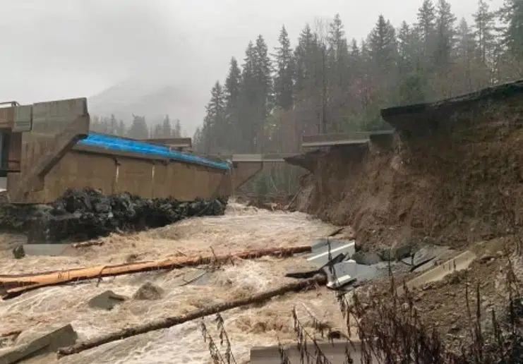
A washed out section of the Coquihalla highway north of Hope on Nov. 16, 2021. (Photo via Jeremiah Steberl)
The General Manager of Yellowhead Road and Bridge says crews are still trying to determine the extent of the damage on the Coquihalla between Hope and Merritt.
However, speaking on the NL Morning News, Dave Duncan, says it is not clear how long the highway will be closed for, but he noted it could be several days.
“We know that we are going to have work to do there to rebuild some sections of road that are compromised and construction this time of year is going to be challenging because we’re going to be doing it in a condition where we’re likely gonna have snow,” he said.
“I think I can say with a higher degree of confidence the highway will be closed for some time here. Whether that is multiple hours or multiple days, we’ll know more over the course of the day today. I know that the Ministry of Transportation, the province is fully mobilizing.”
The worst damage to the highway appears to be just north of Hope, near the Othello Road exit. Photos from the scene show a massive washout with water flowing through lanes of the freeway.
“Really wet and soggy here in Merritt. Up on the Coquihalla, we’ve seen over 200 mm of rain. It started to come down as snow. We had about 10 cm of snow Saturday night, then it switched to rain and it hasn’t stopped since,” Duncan added.
“We’ve got another 50 mm coming today and I don’t think it is unsafe to say that is unprecedented.”
Paula Cousins with the Ministry of Transportation said Monday morning that officials will keep the public updated once they gauge the extent of the damage and the work that lies ahead.
“Safety is our highest priority,” she said. “We’re also expecting the potential for some snow on the corridor for the afternoon, which will add to our challenges.”
“Our experts are going to fly the corridor as soon as they’re able to get up there. But we do have early reports that there is some damage along the corridor. Although it’s too soon to know the full extent of that damage, which is going to determine the length of closure.”
In an update on Monday afternoon, Public Safety Minister, Mike Farnworth, said on some highways it may be as simple as removing debris and ensuring the road is good for vehicles to go through again.
“In the case of the Coquihalla, I have not seen a detailed report on that, but from what I have heard, there does appear to be a significant issue on one side of the highway,” he said.
“Obviously we’re going to have to wait for the full geotechnical reports on that before we’re able to say, look, it’s going to be open in X amount of days or X amount of weeks.”
Environment Canada Warning Preparedness Meteorologist, Armel Castellan, said Monday afternoon, another threat right now is strong wind, and in the Interior, colder air.
“On the highways, the freezing levels are going to drop. So, even if you’re not dealing with snow because you’re not dealing with precipitation any more, we’re dealing with something like a flash freeze warning,” he said.
“Not quite at that level, but still I believe there will be some localized freezing of the water that has fallen.”
Highway 1 also washed out at Tank Hill rail overpass
Aerial photos published by the BC Government also showed that Highway 1 – the other main highway from Kamloops to the Lower Mainland – also appears to be damaged by floods at the Tank Hill rail overpass, east of Lytton.
In the Monday afternoon update, Cousins said there is no estimate as to when this highway could reopen as well, effectively cutting off access between Vancouver and the Lower Mainland, and the rest of Canada. Highway 99 remains closed as well, because of mudslides.
The rail line at Tank Hill appears to be intact at this time, however both CN and CP Rail said this morning that trains between the Southern Interior and the coast are not running because of mudslides on their tracks.
Earlier this morning, the entire City of Merritt was ordered to evacuate because of heavy flooding. The Thompson Nicola Regional District has also issued a large scale evacuation alert for rural areas downstream of Kamloops Lake.
A look from a flyover of #BCHwy1 at Tank Hill near Lytton and Nicomen.
For the latest #BCStorm travel info, check @DriveBC‘s website: https://t.co/0sq39Ad5WN#TransCanadaHighway pic.twitter.com/N4zVto5vNK
— BC Transportation (@TranBC) November 15, 2021


