Mountain snow/via Watershed Watch Salmon Society
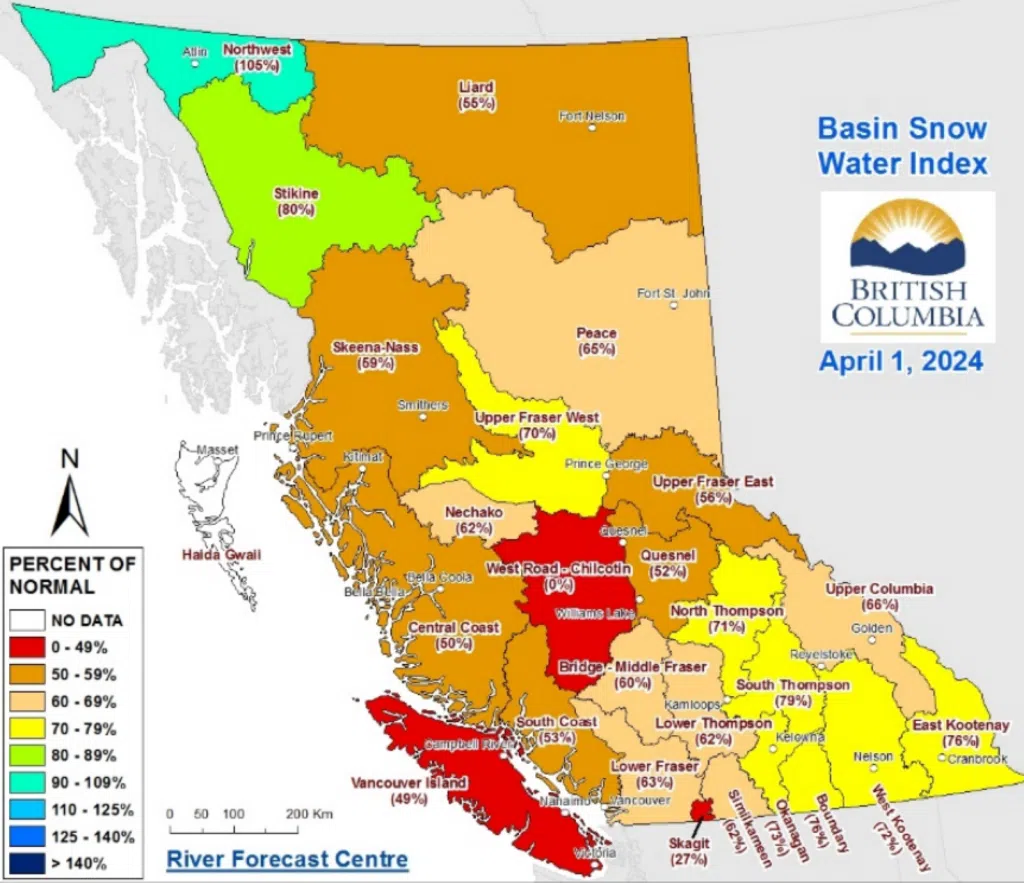
Snowpack levels across the province are very low, according to the B.C. River Forecast Centre’s April 1st readings.
Hydrologist Jonathan Boyd presented the latest information on Wednesday and says the average of all snow measurements across the province is 63% of normal.
“That’s a drop from March 1st when the value was 66% of normal and significantly lower than last year when April 1st, 2023 was 88% of normal,” cautioned Boyd.
In terms of the Kamloops area, the North Thompson Snowbasin index for April 1 is 71% of normal, down by five percentage points compared to March 1.
The South Thompson is 79% of normal, dropping by 11 percentage points.
“It’s really interesting to see the different variety and variability of the snowpack throughout the province so the Lower Mainland and Vancouver Island can have values as low as 13%, but as high as 200% of normal for April 1. The North and South Thompson don’t necessarily vary that much. So even though the South Thompson is the 79th percentile, there was a station that was recording the record low there. So from a percentile perspective, it is very low.”
- Snowpack readings as of April 1, 2024/via BC River Forecast Centre
Boyd says this suggests the threat of flooding is quite low for the Thompson Rivers.
“Anything upstream of of Kamloops, the Shuswap lake, the North Thompson river, McClure, the Salmon River, there’s always the potential for rain events to affect smaller tributaries smaller creeks and rivers,” noted Boyd. “But from the bigger perspective, it will be more of a low flow situation that will be the concern from a drought level perspective.”
Boyd notes they usually have a better understanding of the impact on drought levels after the snowmelt period.
“We’ll see what happens over the next maybe three to four weeks in terms of temperatures,” said Boyd. “Ideally what we’d like as kind of what’s happening over the past maybe 10 days or so, which is seasonal temperatures with a little bit of precipitation and there has been some seasonal accumulation that’s occurred over the first week of April.”
In terms of the how this potentially impacts fire season in the area, Boyd says there is a lot more too it then the snowpack.
“Snowpack is just one part of the story there and a big aspect is the May and June precipitation.”
Boyd pointed to 2019 as a year where precipitation lingered, even into July and August.
“Typically speaking, drought and wildfire go hand in hand. So yeah, it’s not setting up to be a great season, but it still just depends on what the weather conditions are,” noted Boyd. “If we have last year’s spring weather conditions this year, it will be worse from a drought perspective.”


