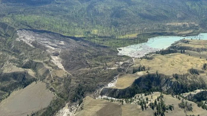
Aerial photo of Chilcotin slide zone/via Willie Sellars
Emergency Management Minister Bowinn suggests the current modelling shows water from a vast lake forming behind a landslide damming the Chilcotin River is unlikely burst through in a sudden release.
Water, Land and Resource Stewardship Minister Nathan Cullen says the province is doing 2D mapping of the slide and says they’re looking at two different scenarios.
“The lake level might rise to the point where water begins to flow over the top of the dam and re-enter the riverbed below,” said Cullen. “It’s also possible that the water will seep through the dam and make its way downstream that way.”
The slide itself is now listed as one kilometer long, 600 meters wide, and 30 meters deep.
The BC government says it’s still not known when the water may start flowing again on the Chilcotin River, but says communities downstream will be sent alerts if necessary.
Others preparing for outflow
The Thompson Nicola Regional District is keeping close tabs on the situation in the Chilcotin, as any outflow from the landslide area will cross through the Fraser River in TNRD jurisdiction.
“A lot of unknowns and no definitive information on when or if it may breach,” said Mike Knauff, Director of the TNRD’s Emergency Operations Center. “What we’re doing in preparation is we’re looking down the Fraser at any property points that may be within the TNRD, just so we have a really good awareness of where the risks may be for residents.”
Meanwhile, Yellowhead Road and Bridge which operates the Lytton Ferry says they will be able to pull the vessel out of the Fraser River if a debris flow heads downstream.
However, it notes the ferry dock is mounted into the riverbed, meaning it can’t be moved, and could face potential damage from debris.
Interior Health has decided to move 21 long-term care residents out of Lillooet as a precaution.


