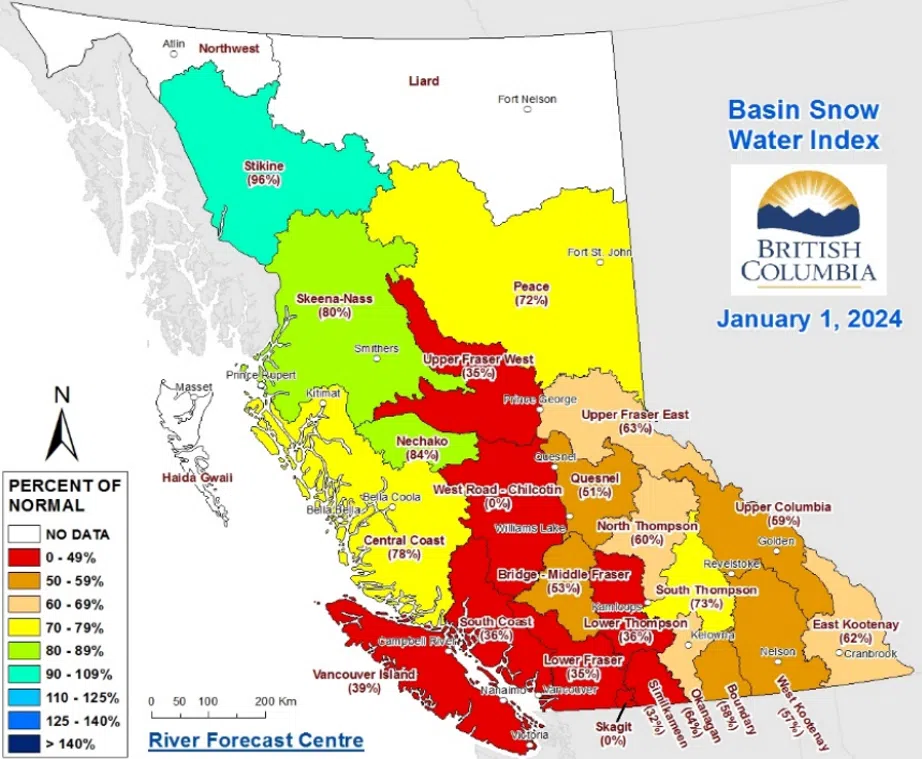
A map at the various snowpacks across B.C. as of Jan. 1, 2024. (Photo via BC River Forecast Centre)
The first look at snowpack data from the BC River Forecast Centre is painting a dire picture for the upcoming summer.
The data from Jan. 1, which was released Wednesday, shows the provincial snowpack is just 56 per cent normal for this time of year, which “could significantly affect ongoing drought concerns into the summer.”
“For the second year in a row, a significant drought extended into the fall for much of the province,” the River Forecast Centre said. “October was drier and warmer than normal [while] November temperatures ended up near normal due to a significant cold period in the last week of the month, while precipitation was unusually dry throughout B.C.”
“Upcoming challenges related to drought could include water supply issues, low groundwater levels, inadequate river levels for cultural needs, environmental flows, agricultural use, power generation, recreational use, wildfire risk, and more.”
Speaking on Radio NL, Hydrologist Jonathan Boyd said he was “pretty surprised” by how low the overall provincial snowpack was.
“Last year, I remember a lot of news outlets were considering the January 1 bulletin to be well below normal at 82 per cent, and I was cautiously saying ‘well, its just a little bit below normal. It could be worse’ and we’re really seeing it a lot worse this year,” he said.
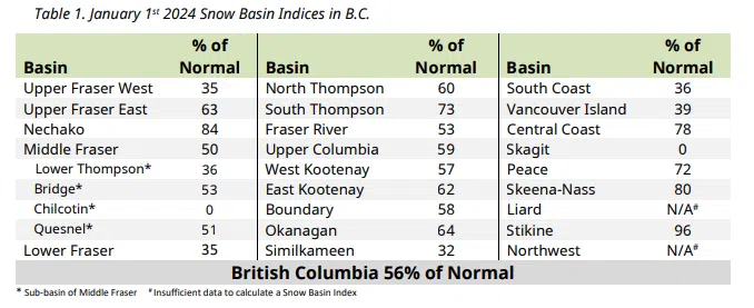
In the Kamloops-area – which recorded the warmest and driest year on record in 2023 – the current snowpacks are in a little bit of a better shape with the North Thompson sitting at 60 per cent of normal and the South Thompson at 73 per cent of normal.
Elsewhere in B.C., the Okanagan snowpack is at 64 per cent, the Upper Columbia is at 59 per cent, the Middle Fraser snowpack is at 50 per cent, the Lower Fraser at 35 per cent, the Lower Thompson is at 36 per cent, and the Similkameen is at 32 per cent.
Other areas like the Skagit and Chilcotin – a sub-basin of the Middle Fraser – reported no snowpack.

A look at the various snow indices across B.C. as of Jan. 1, 2024. (Photo via BC River Forecast Centre)
“Fifteen snow stations measured all-time record low snow pack with five occurring in the Lower Fraser and four within the Upper Columbia snow basins,” the River Forecast Centre added. “Due to the extremely low snow conditions, below normal hazard for spring freshet related flooding is emerging, especially in the Interior.”
The Stikine basin in northern B.C. reported the highest snowpack at 96 per cent of normal while the Liard and Northwest basins had insufficient data.
“There are still three or more months left in the snow accumulation season and the snow pack can still change significantly based on upcoming weather patterns,” the River Forecast Centre added.
“The first few days of January remained dry, until an active pattern moved in beginning January 5, bringing additional precipitation and snow to the province. The rate of mountain snow accumulation since January 1 has been typical. Beginning January 10, an arctic outbreak is expected to impact the province with very cold temperatures forecast for the upcoming week.”
The next release of snowpack data is scheduled for Feb. 8.
For the entire Snow Survey and Water Supply Bulletin report, go here.


